Wegbeschreibung zum Projekt Kuckucksmühle

Die Adresse
Kuckucksmühle
Ausbau 7
16909 Heiligengrabe
(Brandenburg)
Deutschland
Koordinaten
Anfahrt mit der Bahn
Der nächste Bahnhof ist Liebenthal (OPR) (7km) manchmal bezeichnet als Liebenthal (Prignitz) - Im Zug muss man den Haltewunsch für diesen Bahnhof mit dem STOP-Knopf betätigen, weil der Zug sonst eventuell nicht anhält!
Wenn es später wird (bis 22:00) ist Wittstock (Dosse) günstiger, nicht zu weit weg (10km) und auf der gleichen Strecke wie Liebenthal (OPR).
Zu manchen (seltenen) aussergewöhnlichen Gelegenheiten ist Blumenthal(Mark) auch eine Option, liegt aber auf einer anderen Strecke und fährt nur einige Male am Tag (7km).
Du kannst Deine Bahnreise hier planen: diese Webseite.
Mit dem Auto
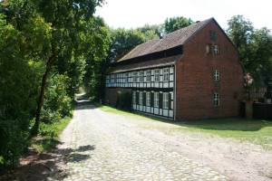
Autobahn A 24 Abfahrt 21. Wenn du aus Berlin kommst, nach der Ausfahrt links abbiegen, wenn du von Hamburg/Rostock kommst nach rechts, bis zum Dorf Herzsprung. Biege links auf die L14 nach 'Kyritz' und rechts am Ende des Dorfes (Herzsprung) nach Koenigsberg/Blumenthal/Grabow. In Grabow die zweite rechts abbiegen (Ortsmitte/Eichbaum) dann am Ende links aus dem Dorf hinaus. Folge der Strasse für 4 Kilometer (bitte die Geschwindigkeitsbegrenzungen auf 50 und 30 Kmh beachten! Kinder und Tiere laufen über die Strasse, andere Fahrzeuge können hinter jeder Kurve entgegenkommen) und wenn die Strasse in Kopfsteinpflaster übergeht, stehst du schon vor der Mühle.
Daneben hast du viel Platz zum Parken. Bitte parke nicht direkt vor dem Tor, dies ist eine Feuerwehrzufahrt!
Mit dem Fahrrad oder Trampen
Um dich allein auf dem Weg zurechtzufinden, kannst du diese Karte benutzen: OSM Bicycle map. Navigationssysteme leiten dich bis Grabow oder Blandikow, aber sie wissen oft den weiteren Weg nicht. Bitte schau dir die Karte an, bevor du losfährst, weil unterwegs nicht überall guter Netzempfang ist.
Auch interessant: Conditions for a visit at Kuckucksmuehle
operating instructions
Various functions are available as part of the map.
mouse/touch operation
- moving by grabbing the map with a mouse-click you can move the map around
- overview map using the < button in the bottom right of the map you can expand an overview map
- zooming in and out using the + and - buttons in the top left of the map you can obtain more or less detail in the map
- switching themes or maps clicking on the ≡ icon on the right-hand side of the map you can view and select available maps and themes
- retrieving information the map may contain elements that contain more information, by clicking these a popup will show this information
- fullscreen display using the ⛶ button the map can be maximized to fullscreen display, use the ▢ button to return to page display.
keyboard operation
Keyboard operation becomes available after activating the map using the tab key (the map will show a focus indicator ring).
- moving using the arrow keys you can move the map
- overview map using the + button in the bottom right of the map you can expand an overview map
- zooming in and out using the + and - buttons in the top left of the map or by using the + and - keys you can obtain more or less detail in the map
- switching themes or maps clicking on the ≡ icon on the right-hand side of the map you can view and select available maps and themes
- retrieving information the map may contain elements that contain more information, using the i key you can activate a cursor that may be moved using the arrow keys, pressing the enter will execute an information retrieval. press the i or the escape key to return to navigation mode
- fullscreen display using the ⛶ button the map can be maximized to fullscreen display, use the ▢ button to return to page display.
It's possible that some of the functions or buttons describe above have been disabled by the page author or the administrator

| id | symbol | latitude | longitude | description |
|---|---|---|---|---|
| 1 | 53.10347º | 12.40463º |